Connect with us

States

10 U.S. States Facing Major Tourism Losses This Summer

Published

on

10 U.S. States Facing Major Tourism Losses This Summer
Juliana Malta/Unsplash

Planning your summer escape? You might want to double-check the mood first. Some states are sweating more than sunscreen sales, thanks to weather woes, travel shifts, and rising costs. Before you book that getaway, see which spots are struggling to keep vacationers coming.

California

California
Lewis McNeal/Pexels

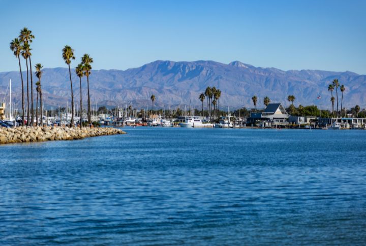
California saw international arrivals drop by 11% year-over-year, thanks to rising political tensions and a strong dollar. Still, the Golden State holds its global charm. Tourism officials are now rolling out fresh campaigns aimed at drawing more international travelers back.
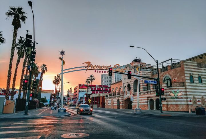
Nevada

Nevada
Anas Jawed/Pexels

Las Vegas is doubling down on new conventions and local deals as it faces a rough patch—convention bookings fell 15%, and slot machine revenue has declined for three months straight. The city’s resilience lies in constantly reimagining how to keep guests coming.

New York City

New York City
Lukas Kloeppel/Pexels

Hotel revenues in NYC may fall by $1.2 billion this summer, partly due to sluggish international traffic through JFK and LaGuardia. Pre-pandemic levels still feel out of reach. To counter the dip, the city is betting big on fresh events, local offers, and travel campaigns.

Colorado

Colorado
Spencer Gurley Films/Pexels

Off-peak travel campaigns are gaining traction across Colorado, aiming to spread visitation beyond crowded summer weekends. But with national park reservations dropping 17% and Denver airfare climbing 18%, many hikers may be scaling back on their Rocky Mountain travel plans this year.

Hawaii

Hawaii
Jess Loiterton/Pexels

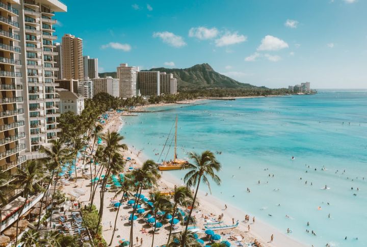
Tourism in Hawaii cooled this spring, with March 2024 showing a 5% decline in both visitors and spending. Cost concerns and economic jitters may be partly to blame. State leaders are now pushing off-peak travel as a way to stabilize the seasonal dip.

Arizona

Arizona
Dziana Hasanbekava/Pexels

Summer heat scorched Arizona’s numbers last year, cutting Phoenix tourism by 12% and triggering 30% cancellations at Grand Canyon lodges. Still, the state remains a draw for outdoor enthusiasts while steering more attention toward indoor attractions that offer relief from the rising heat.

Alaska

Alaska
mpmd2009/Pixabay

Alaska still shines as a cruise destination, thanks to creative promotions targeting independent travelers. But cruise passenger numbers are down 9% from 2023, and the state’s tourism workforce hasn’t yet bounced back to where it stood before the pandemic hit.

Louisiana

Louisiana
djnaquin67/Wikimedia Commons

Jazz Fest attendance dropped by 30,000 this year, and summer hotel reservations are lagging. Analysts blame airfare hikes and early hurricane anxiety. While tourism’s pace is slower than usual, Louisiana’s event lineup is as bold as ever, hoping to reignite interest before fall.

Washington

Washington
JOHN CALLERY/Pexels

Mount Rainier visits plunged 22% last June, and Seattle hotels are still trailing their West Coast rivals in bookings. Still, Washington isn’t losing steam—tourism leaders are spotlighting quieter seasons as the smart choice for adventure seekers who want more room to roam.

Texas

Texas
Quintin Soloviev/Wikimedia Commons

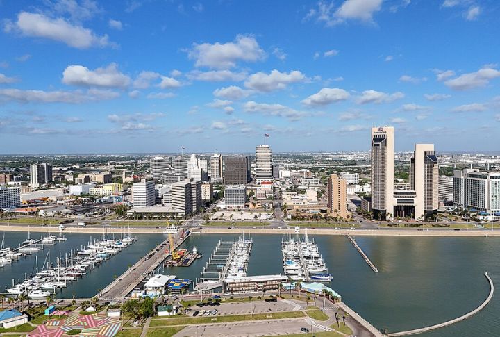
Beach visits to Corpus Christi and Galveston have dropped by over 20%, with July’s heat forecasts already triggering cancellations. Despite the challenges, Texas beaches still draw loyal crowds, and local businesses are stepping in with deals to keep the traffic flowing.

Continue Reading
Click to comment

Leave a Reply

Your email address will not be published. Required fields are marked *

California

10 Insights About California’s Breakaway Fault

Published

on

USGS/Wikimedia Commons

California is a playground for restless fault lines. While everyone talks about the San Andreas, the Breakaway Fault has been making its own quiet moves beneath the surface. Scientists are still piecing together its story, and what they’ve found is shaking up old assumptions. So, here are ten insights into this mysterious fracture that could change how we see California’s seismic future.

A Result Of Crustal Stretching

John Wiley/Wikipedia

Crustal stretching comes first by deep mantle convection and plate movements. Breakaway faults appear later, forming as the crust pulls apart and weakens. In regions like the Range Province, these faults develop as the land extends, exposing deep-seated rocks. Hence, without stretching, breakaway faults wouldn’t exist at all.

California’s Breakaway Faults Date Back Millions Of Years

NASA/Wikipedia

These faults aren’t just old—they predate most of the state’s modern geography. Geological studies reveal that California’s breakaway faults began forming over 23 million years ago during the Miocene Epoch. This period saw intense crustal stretching. Hence, it carved out regions that would later evolve into today’s Mojave Desert, Death Valley, and parts of the Basin and Range Province.

Earthquake Risks Depend On Fault Movement

Ikluft/Wikipedia

Cracking ground? Maybe. Not all breakaway faults cause earthquakes, but their movement influences seismic hazards. Some transition into active faults capable of generating quakes. Others simply mark past crustal shifts. Seismologists study their movements closely because, in earthquake-prone California, even an ancient fault can have a few surprises left in store.

Breakaway Faults Open Pathways For Magma

Hawaii Volcano Observatory (DAS)/Wikipedia

When the crust pulls apart, it does more than just crack—it creates channels for magma to rise. Breakaway faults can connect deep heat sources to the surface, fueling volcanic fields and geothermal hotspots. Plus, in places like the Coso Volcanic Field, ancient faulting helped shape the region’s bubbling springs and hidden magma chambers.

These Faults Help Form Basins

Erthygy/Wikipedia

Low-lying basins don’t form randomly. Breakaway faults play a key role, pulling apart crust and leaving behind sunken valleys. California’s Mojave Desert and Death Valley owe much of their topography to this process. Sediments pile into these depressions over millennia, further creating landscapes that tell a silent yet powerful story of geological forces at work.

The Whipple Mountains Reveal Deep Rock History

http://www.terraprints.com/Wikipedia

Geologists dream of seeing deep into the Earth’s crust, but breakaway faults do the work for them. In places like the Whipple Mountains, these faults have lifted ancient rocks from deep underground. These rocks offer rare insights into high-pressure minerals, deep crustal deformation, and the mechanics of fault-driven uplift.

These Faults Shape California’s Waterways

Mav/Wikimedia Commons

Water follows the cracks. Rivers and lakes often align with geological faults, and breakaway faults influence their courses. In places like the Owens Valley, shifting land has redirected water flow for millions of years. If you’ve ever wondered why some rivers take unexpected turns, hidden fault lines beneath your feet might be the answer.

Old Faults Still Influence The Region

Hear2heaL/Wikipedia

A fault doesn’t have to be active to leave a lasting impact. Many breakaway faults stopped moving millions of years ago, but their legacy remains in the form of steep cliffs and tilted rock formations. These old faults serve as boundaries between uplifted blocks and sunken basins, hence proving that even when they stop moving, their impact lingers for eons.

Scientists Use Dating Methods

Didier Descouens/Wikipedia

Unlocking fault histories requires precision. Geologists use radiometric dating to determine when faults last moved. In California, potassium-argon and uranium-lead dating have revealed essential timelines for breakaway faults. Knowing their ages helps reconstruct past tectonic shifts. Lastly, it allows scientists to predict how extension zones might behave in the future.

The Government Monitors Them For Hazards

Alissa Walker/Wikipedia

California’s Office of Emergency Services, along with USGS and CGS, focuses on assessing seismic hazards. Major fault zones like the San Andreas Fault receive the most attention, while older or inactive normal faults are studied less frequently. Still, mapping these faults helps understand the long-term risks of crustal shifts.

Continue Reading

Colorado

10 Discoveries That Put Colorado On The Archaeology Map

Published

on

Lacee Curtis/Wikimedia Commons

Colorado has layers of history hiding beneath the surface, and archaeologists have been discovering mind-blowing finds. Some discoveries answered big questions, others raised even bigger ones, and a few left experts completely stumped. So, if you thought Colorado’s past was all gold rush and cowboys, think again—these ten finds prove there’s way more to the story. Let’s start digging!

Ancient Puebloan Calendar Petroglyphs

Jeff Albright/Wikimedia Commons

Long before clocks or calendars, the Ancestral Puebloans used the sun to track time. At Castle Rock Pueblo, spirals carved into rock, discovered in 2023, mark solstices and equinoxes. As the sun moves, its light and shadows align with the carvings to create a natural calendar.

Snowmastodon Ice Age Fossils

Sergiodlarosa/Wikipedia

Beneath a Colorado ski resort, an ancient world remained hidden for thousands of years. That changed in 2010 when construction crews at Snowmass Village uncovered over 5,000 fossils. These remains, dating back 120,000 years, offer a rare look at Colorado’s prehistoric wildlife and climate.

Magic Mountain Archaeological Site

Jeffrey Beall/Wikimedia Commons

People have lived in Colorado for thousands of years, and Magic Mountain proves it. Buried beneath the foothills near Golden, this site holds 7,000 years of history. Archaeologists have uncovered stone tools, fire pits, and trade goods, showing it was more than a campsite—it was a thriving gathering place.

Joe Ben Wheat Site Complex

Jeffrey Beall/Wikipedia

This settlement, excavated by archaeologist Joe Ben Wheat, housed over 100 rooms. Built between A.D. 675 and 1300, its artifacts reveal advanced farming and an interconnected society. The sheer scale of the ruins offers a glimpse into the everyday lives of people who shaped the Southwest’s ancient civilizations.

Heleocola Piceanus

Dongju Zhang/Wikimedia Commons

Teeth don’t lie. A single fossilized jawbone, unearthed in 2024, identified a mammal that lived alongside dinosaurs 70 million years ago. Nicknamed the “swamp dweller,” Heleocola piceanus was small, but its discovery helped scientists reconstruct Colorado’s prehistoric ecosystems before the asteroid hit.

Sun Temple

Ken Lund/Wikimedia Commons

Built with precision yet never completed, this D-shaped structure raises more questions than answers. Constructed around 1250 A.D., it suggests Ancestral Puebloans followed celestial cycles. Why was it abandoned? Some speculate societal shifts. However, the truth remains buried in the sandstone ruins.

Canyons Of The Ancients 

Nationalparks/Wikipedia

Ancestral Puebloans built homes, carved petroglyphs, and gathered in kivas across 176,000 acres, making Canyons of the Ancients one of the most archaeologically dense sites in the U.S. With over 8,000 ruins, it preserves evidence of farming, trade, and daily life—still standing in their original locations.

Franktown Cave

Bcexp/Wikipedia

Franktown Cave holds some of Colorado’s most unique archaeological finds. Artifacts such as seashells and minerals from distant regions indicate that trade networks extended far beyond Colorado. Hence, this site provides one of the most detailed records of early inhabitants.

Indian Mountain Stone Circles

Chris Light/Wikimedia Commons

Rocks don’t move themselves. Ancient builders placed these stone circles near Lyons, Colorado, over 1,500 years ago. Archaeologists discovered pottery fragments and fire pits, proving that Plains and Woodland cultures gathered here. Plus, each formation reveals movement patterns and early survival strategies.

Dinosaur Tracks

cm195902/Wikimedia Commons

Dinosaurs walked through Picketwire Canyon 150 million years ago, leaving behind the largest track site in North America. Some tracks measure over three feet across. Unlike fossilized bones, footprints capture moments in time and further reveal how these creatures actually lived.

Continue Reading

Minnesota

10 Brewing Legacy Lying Under Minnesota’s River Valleys

Published

on

McGhiever/Wikipedia

Minnesota’s river towns are steeped in brewing history that dates back to the 19th century. Beneath these charming towns lies a network of caves that once served as the backbone of local brewing. These hidden havens tell the story of how early brewers used natural landscapes to perfect their craft. Let’s uncover 10 beer havens.

Wabasha Street Caves In St. Paul

Jonathunder/Wikipedia

These sandstone caves, carved in the 1840s, were an important part of St. Paul’s brewing history. Their naturally cool temperatures made them perfect for storing and aging stout. Years later, they became a secret gathering spot during Prohibition.

Schieks Cave Beneath Minneapolis

BpA9543/Wikipedia

Hidden under Minneapolis, Schieks Cave gave early brewers a cool place to ferment their brew. This large cave was shaped by erosion and mining, and it helped local breweries thrive in the 19th century. It shows how brewers once relied on nature to create great lager.

Joseph Wolf Brewery Caves In Stillwater

Dougtone/Wikimedia Commons

Stillwater’s Joseph Wolf Brewery was founded in 1868. It relied on its hillside caves to store and age its ale, mainly lagers, which were highly popular then. The brewery thrived for decades and became a cornerstone of Stillwater’s economy and culture.

Brownsville Brewery Caves In Brownsville

Wikideas1/Wikipedia

Carved into the bluffs of Brownsville, these caves served as storage for the town’s mid-19th-century breweries. Although the breweries eventually closed, the caves remain as enduring symbols of early brewers’ methods to overcome technological limitations.

Minneiska Brewery Caves In Minneiska

Jonathunder/Wikipedia

The Minneiska Brewery operated in the late 1800s. It made extensive use of natural caves for aging and storage. The brewery produced lagers and ales that were well-regarded locally, with the caves playing a significant role in ensuring their quality and consistency.

Caves of Faribault In Faribault

The Dye Clan/Wikimedia Commons

Faribault’s caves, initially used by Fleckenstein Brewery in 1856, were critical for an aging brew before refrigeration was available. It was, however, later repurposed for cheese aging. These sandstone caves demonstrate how natural spaces serve diverse purposes.

Jordan Brewery Caves In Jordan

Oneconscious/Wikimedia Commons

The caves at the Jordan Brewery were essential to its operations in the 1860s. Dug into the hills, they maintained steady temperatures year-round. The brewery produced popular ales that gained local recognition, and the caves played a key role in ensuring their quality.

Historic Brewery Caves In Hastings

Ammodramus/Wikimedia Commons

Dating back to 1856, Hastings’ brewery caves served as essential storage for one of the state’s earliest breweries. They maintained ideal temperatures for fermentation and aging. These vaults played a key role in producing high-quality stout that supported the local industry.

Sugar Loaf Brewery Caves In Winona

McGhiever/Wikipedia

Beneath Winona’s iconic Sugar Loaf bluff, these caves provided vital storage for ale brewed in the 1860s. Their limestone structure ensured the right conditions for aging, and they remain a physical reminder of Winona’s brewing legacy.

Schmidt Brewery Caves In St. Paul

Northfielder/Wikimedia Commons

During the late 1800s, Schmidt Brewery relied on these caves to perfect the lagering process. The brewery was one of Minnesota’s most iconic ale producers, and its success helped establish St. Paul as a central hub in the state’s burgeoning brew industry.

Continue Reading

Trending

Copyright © 2025 CityStateZipCode.com